Urbanissta Ltd, Eastside, Kings
Cross, London, N1C 2AX
Urbanissta London: 020 7459 4549
Urbanissta Birmingham: 0121 517 1251


Urbanissta Ltd, Eastside, Kings
Cross, London, N1C 2AX
Urbanissta London: 020 7459 4549
Urbanissta Birmingham: 0121 517 1251
11th November 2025
Final Submission Update – 15th December 2025
Following extensive consultations and feedback from key stakeholders and local residents, the final planning submission was sent to Rochford District Council on 1st December 2025. The application is now available on their website under Planning Reference: 25/00644/OUT.
Addressing Your Feedback
During the consultation period, we received a wide range of comments and suggestions. Below, we’ve highlighted some of the main concerns raised and outlined our responses to each:
Infrastructure Overload
Residents expressed concern over existing infrastructure stating that it is already overstretched and cannot support 325 additional homes. Other concerns included:
Healthcare
Education
Utilities
Emergency services
| Croudace response: Healthcare & Emergency Services – contributions for such will be provided as required. Education – contributions for such will be provided as required. Utilities – A ALP Drainage Technical Note has been submitted to the council which can be viewed online. |
Traffic, Highways & Road Safety
Concerns included:
Traffic congestion
Road safety
Access design criticisms
Equestrian safety
Cumulative impact
| Croudace response: Essex County Council have not raised any objections in respect of the planning application and are seeking a financial contribution towards offsite highway improvements. |
Loss Of Green Belt / Open Countryside
Residents expressed concerns over:
Key points included:
| Croudace response: Our submission demonstrate that the site is ‘grey belt’ land as defined by the NPPF and this was confirmed by RDC at pre app stage. Rochford District is an area with demonstrable housing need. The site is in a sustainable location and will provide 50% of the new homes as affordable dwellings. |
Environment & Ecology
Comments from residents included:
Wildlife loss
Flooding & drainage
Climate change & food security
| Croudace response: Our submission demonstrates that biodiversity net gains will be increased by circa 22% for habitats, 31% for hedgerows and 78% for watercourse gains. In additional 10.86ha of new publicly accessible green space will be provided. |
Heritage Impact – Pelhams Farmhouse (Grade II Listed)
Several detailed objections related specifically to the Grade II listed Pelhams Farmhouse, which borders the site.
The respondents had concerns over:
| Croudace response: An Archaeology and Heritage Technical note has been prepared by Border Archaeology and is submitted in support of the resubmission which specifically concludes that less than substantial harm on the setting of Pelhams Farmhouse. |
Quality of Life & Community Impact
Concerns included:
| Croudace response: The application is supported by a heath impact assessment which specifically address the impacts of the development om the health of local people and new residents. Overall, it indicates that subject to the implementation of certain recommendations, will result in a net positive to the health of those who will live on the Site, as well as residents of the local area. The main recommendations, cover aspects such as: Disturbance & Stress Caused by Construction Activities Access to Services and Health Inequalities Development Design and Green Spaces Further Engagement |
Archaeological trial trenching
Please note – archaeological trial trenching will be carried out on site starting Tuesday 11th November, for a period of approx 4-6 weeks.
The team will be working on site between 7:30am – 4:30pm each day.
The works will involve the careful removal of topsoil in designated areas to allow for archaeological investigation. Once the trenching is complete, the areas will be backfilled to restore the site.
This work is not commencement of development it is a requirement for the archaeological exploratory work to take place before the Council can make a decision on the outline planning application.
Submission – 2nd September 2025
A submission has been made today, 2nd September 2025 in relation to the Land North of Rochford. Please note that this application is currently pending validation and we will provide further updates once once the validation process is complete.
Our Proposal and background information:
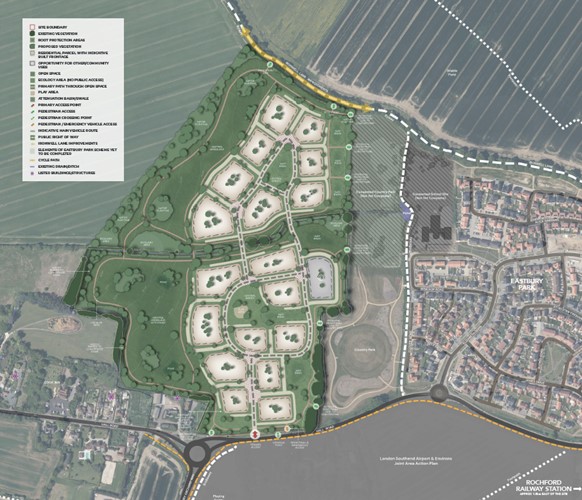
We are proposing a vibrant new community with up to 300 homes including 50% affordable housing supported by significant green spaces, play areas, and sustainable drainage systems, on land north of Hall Road, Rochford.
We intend to submit an Outline Planning Application to Rochford Council in early 2025, and we are eager to hear the thoughts and feedback from local people.
Our Proposals Comprise:
Up to 300 homes of mixed sizes to meet local need, including 50% affordable housing. Our plans also include:
Sustainable Transport Links
Improved access to local facilities, enhanced public transport and car club vehicles, including new footways, cycleways, a crossing point, and off-road links to boost sustainable transport options.

Improved Biodiversity
Protect & create natural habitats through designated ecology areas, new trees and hedgerows, meadows and other planting. We will increase the biodiversity of the site in excess of 10%.
Meeting housing needs
The development aligns with government ambitions to increase housing supply and supports Rochford in meeting its housing targets, balancing environmental, social, and economic priorities for the area’s future.
Public consultation
When creating a new community, we value input from local people. We invite you to share your feedback on the proposals.
Frequently Asked Questions:
Q: Who is being consulted?
We have identified 1,406 residential and commercial properties that surround the development area in which we have sent a newsletter and exhibition invite. In addition, we have a dedicated consultation web page with a resident’s survey to be completed.
The Site is within Rochford District Council, we have contacted the local councillors for the area and have been in contact with the local parish councils for both Rochford and Hawkwell. We have also held a pre app meeting with Rochford District Council to further discuss our proposals and timeline.
Q: What will your full application submission include?
Croudace Homes are proposing to build a vibrant new community with up to 300 homes designed to meet housing needs, this will include 50% affordable housing, supported by substantial areas of green space, play areas, and sustainable drainage systems, on land at Hall Road, Rochford.
Q: Will we be able review all the material you submit?
Yes, all the information submitted as part of the full application submission will be accessible for public review, once validated by Rochford District Council.
Q: Will there be a public consultation?
Yes, there will be a public consultation where residents will be invited to share their views and speak with the team.
The public consultation is on:
Date: Thursday 23rd January 2025
Time: 2.00 – 7.00pm
Where: Women’s Institute Hall – 21 West Street, Rochford SS4 1BE
Q: How many houses will be provided?
Up to 300 residential dwellings of mixed sizes to meet local need, including a policy compliant level of 50% affordable housing.
Q: Where is the Site access?
The site will be accessed directly via Hall Road.
Q; What are the parking arrangements?
The proposed levels of car parking will be agreed with the council at reserved matters stage. However, all homes will have car parking and cycle parking, and electric vehicle points will be available for residents. There will also be additional visitor parking to ensure that all parking is accommodated on site.
Q: How will the site be drained?
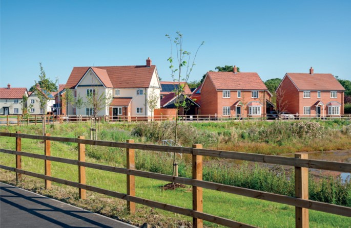
Surface water on site will be drained via a series of above ground attenuation features such as detention basins, which will store and attenuate the surface water across the development and reduce the existing flows into the adjacent watercourses. All surface water drainage systems will be designed to restrict drainage discharge rates to the greenfield 1 in 1 year storm event runoff rate and the basins will provide attenuation for all events up to and including the 1 in 100 year storm event including an allowance for a 40% increase in rainfall intensities as a result of climate change.
Anglian Water has public foul sewers on Hall Road, which is adjacent to the proposed development and a point of connection is proposed close to the entrance of the development. Discussions are ongoing with Anglian Water regarding the exact connection point. Any foul water sewers within the development parcels and offsite to the point of connection are to be offered for adoption to Anglian Water under the Section 104 process of the Water Industry Act.
Q: Does the site have good access to public transport links?
The development will provide improved access to local facilities and public transport, promoting non-car travel. Proposed highway enhancements include new footways, cycleways, a crossing point, and off-road links to boost sustainable transport options. Contributions will be made to support and improve existing and new local bus services.
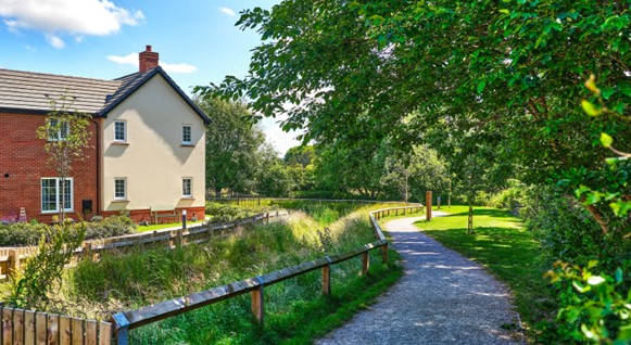
Q: What public open space will there be?
The plan includes large public open spaces, biodiversity net gain areas, and Sustainable Alternative Natural Green spaces (SANG) land, all linked to existing green areas. The design will respect the local architectural character and preserving Rochford and Hawkwell as distinct settlements.
Q: What environmental benefits will the scheme provide?
We have undertaken a Preliminary Ecological Appraisal (PEA) to assess the site’s biodiversity importance, comprehensive details of the flora and fauna on the Site be submitted as part of our outline planning application.
The majority of the site comprises of arable habitats which are of limited ecological interest. The creation of the SANG will provide a mosaic of habitats, including neutral grassland, native scrub, woodland and ponds alongside the development area which will increase the ecological opportunities that the site has to offer. A suite of ecological surveys is currently in progress to provide a robust assessment of the value of the habitats and protected species which are presently using the site. These surveys will advise on any additional recommendations to the masterplan further down the line.
Our plans to further provide biodiversity measures on the site include:
Q: What about the impact on current highways?
We will look at reducing traffic and congestion, including:
Q: How will people get around?
The development will provide a range of opportunities for sustainable travel. These include:
Existing foot and cycleway network enhancements
Public transport network enhancements, including:
Q: I would like to ask a question(s)/give my feedback? How can I do this?
Please complete the survey found on the following link CLICK HERE FOR SURVEY or email info@urbanissta.co.uk
Exhibition Boards
The exhibition panels displayed in the public exhibition are copied below:
Survey
Please click below to fill out the survey:
It is important for us to get your views, as residents of the local community. We would appreciate it if the survey could be completed by 30th January 2025 as this is when our consultation will close. We will then review the comments made and address them in our reserved matters submission.
Please note – Responses received after this date will not be considered.
 Newsletter